Still only one-fifth of the Earth’s ocean floor is mapped
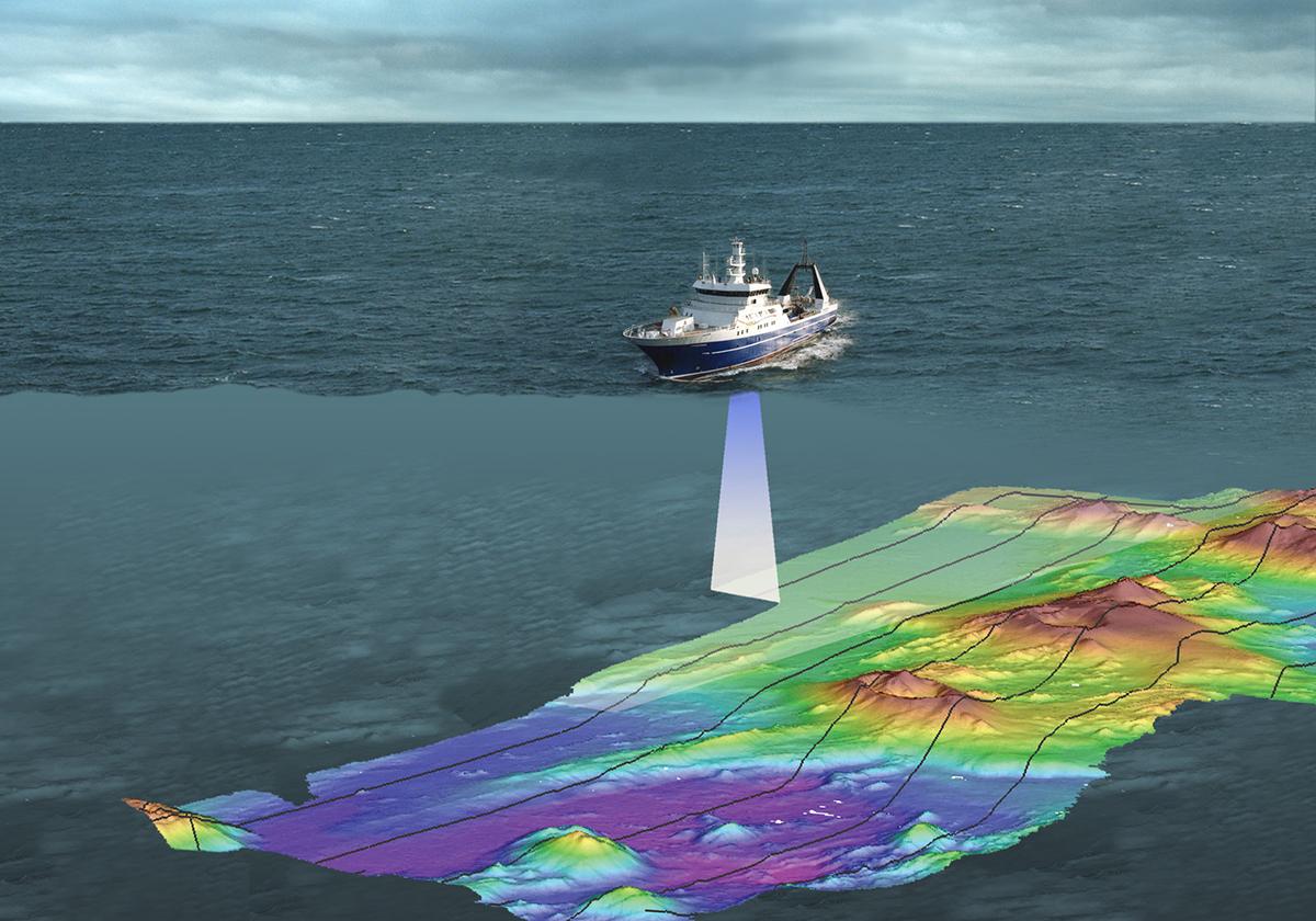
A research ship using sonar for higher-resolution seafloor mapping.
http://www.ausseabed.gov.au/about/mapping
Also known as seabed imaging, ocean floor mapping is the measurement of the depth of the sea bed at a certain point. After obtaining a set of data for such depths, mapping can be done. These maps are known as bathymetric charts and can be used to perform bathymetric studies.
While the history of seafloor mapping goes about 3000 years back, with the first evidence of water depth measurements in historical records from ancient Egypt, its first large-scale scientific application was not until 1870, during the HMS Challenger oceanographic expedition. With the developments of underwater acoustic techniques, the echo-sounding era begins at the beginning of the 20th century[1].
In 2017, when the Nippon Foundation-GEBCO Seabed 2030 Project was initiated, only 6% of the global ocean bottom had been surveyed with modern measurements at a reasonable resolution. Today is number stands at 19% level with more than 80% of this vast underwater realm remaining unmapped, unobserved and unexplored. The GEBCO Seabed 2030 Project’s mission is to bring this to 100% by the year 2030. [2]
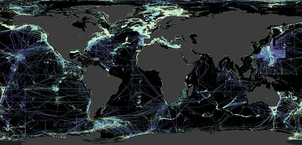
Map showing the areas(black) which are yet to be mapped with reasonable resolution.
About 71% of the Earth’s surface is covered with water and nearly 97% of that water is from our oceans. That is nearly 70% of the Earth’s surface is covered with seawater and underwater. Getting a detailed knowledge of the shape of the seafloor is critical for the safety of navigation and many other offshore applications such as mineral exploration and extraction, offshore wind turbines and deep water research activities. High-resolution seafloor maps provide vital information in tracking and protecting marine life, allowing us to establish solid and sustainable conservation measures. In other words, it's crucial for the safety of marine natural resources as well as humans.
The first measuring devices of depth were sounding poles and lines with weights attached to them. Most of the time, weights made out of lead were used. Sometime later, similar systems using wires and a winch were used for measuring higher depths but these methods were very inefficient and time-consuming.
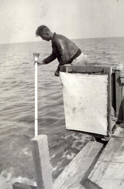
Using sounding pole to measure depths in 1934, Louisiana
NOAA photo library
In order to increase the efficiency and the need to detect underwater objects, exemplified by the search for the Titanic that sank in 1912, as well as submarine warfare during World War I, mapping methods using sound waves started to merge. The development of Single Beam Echo-Sounders (SBES) constituted a significant improvement in terms of accuracy and efficiency over earlier equipment. SBESs are configured with piezoelectric crystal- or ceramic-based transducers that can generate and receive acoustic signals. The depth of the seafloor is determined by measuring the two-way travel time of a sound wave that is sent and reflected back from the sea floor. NOAA OCS

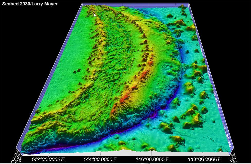
In the 1970s with the development of the satellite-based navigation system global positioning system (GPS), Multibeam echo-sounder systems became popular. Multibeam systems radiate a fan of the sound and listen to the returning echoes of the emitted signals in narrow sectors perpendicular to that fan, resulting in the mapping of a swath of seafloor instead of just a line. Compared to SBESs, they have the advantage of collecting higher-resolution bathymetric data and mapping an area in a much shorter time.
One of the drawbacks of these acoustic methods is that the resolution decreases with increasing water depth. This is due to the expansion of the acoustic beam as it travels through the water column [3]. This challenge could be overcome by using vehicles operated near the seafloor as underwater robots in deep waters.
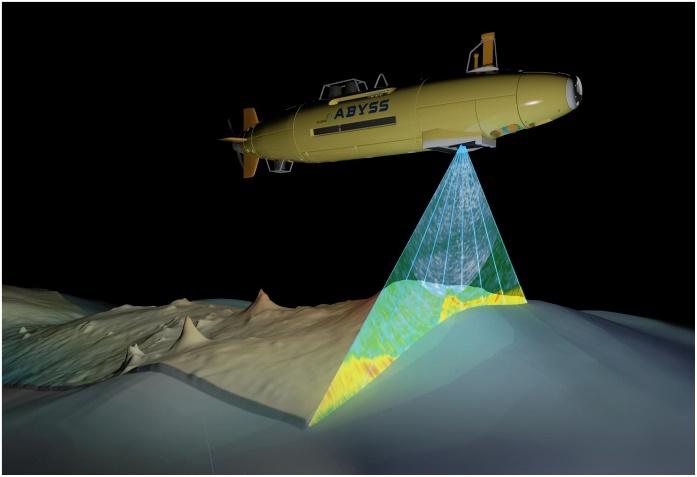
Animated picture of a UAV mapping the ocean floor
GEOMAR
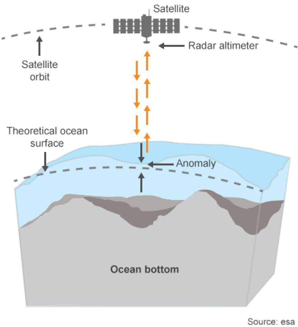
With the development of the satellite industry and more and more satellites being put into orbit enabling high spatial accuracy for environmental measurements globally, Satellite-Derived Bathymetry was used for seafloor mapping in coastal environments. But this method is restricted to a shallow area with high water clarity. Satellite platforms collect data in multiple spectral bands, spanning the visible through infrared portions of the electromagnetic spectrum. Water depth estimations are based on the attenuation of radiance as a function of depth and wavelength in the water column.[4] With the launch of altimetric satellites, satellite-altimetry-derived digital terrain models were developed. These are used to reveal large geomorphological features of the ocean floor.

Seabed mapping using satellites
NASA JPL
Using satellite radar altimeter to map the ocean floor
Another option to map shallow areas is the use of bathymetric LIDAR (Light Detection and Ranging), a technique that transmits laser pulses from an airborne platform and measures their return. The water depth is calculated from the time difference between the reflection from the water surface and the reflection from the seafloor [5]
The newest technology of Photoacoustic Airborne Sonar brings about a revolutionary change in the advancement of seabed mapping techniques. This is a hybrid optical-acoustic system. Engineers at Stanford University have developed an airborne method for imaging underwater objects by combining light and sound to break through the seemingly impassable barrier at the interface of air and water.[6] In this method, the Photoacoustic Airborne Sonar System first fires a laser from the air that gets absorbed at the water's surface. When the laser is absorbed, it generates ultrasound waves that propagate down through the water column and reflect off underwater objects before racing back toward the surface. This allows it to image even through turbid water and carry out large-scale aerial searches of sunken ships and planes and map the ocean depths with a similar speed and level of detail as Earth’s landscapes. This makes it possible to scan the ocean floor rapidly, from a helicopter, rather than relying on a slow-moving ship or submarine.
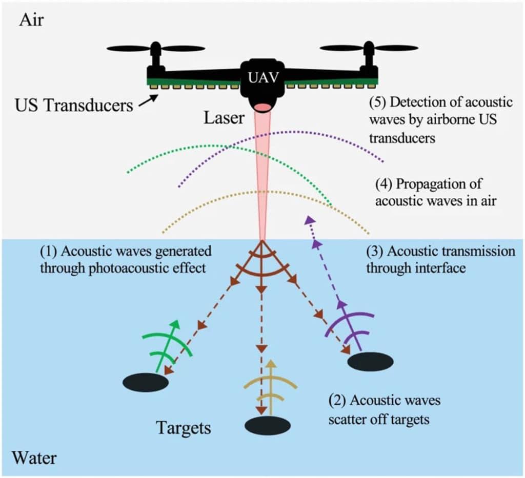
Schematic of Photoacoustic Airborne Sonar System
https://www.inceptivemind.com/photoacoustic-airborne-sonar-system-aerial-underwater-surveys/16484/
With these developments in ocean mapping techniques, it is possible to map the seabed faster and with high resolution. But using these methods to properly map the whole ocean takes some effort. Some of these will come from a great crowdsourcing effort - from ships, big and small, routinely operating their echo-sounding equipment as they transit the globe. Even small vessels - fishing boats and yachts - can play their part by attaching data loggers to their sonar and navigation equipment. And projects should be implemented and carried out in every corner of the world. GEBCO stands for General Bathymetric Chart of the Oceans. It is the only intergovernmental organization with a mandate to map the entire ocean floor. The latest status of its Seabed 2030 project was announced to coincide with World Hydrography Day. Combining all these efforts carried out, it is safe enough to say that we have just become a little more curious about Planet Earth.
REFERENCE
1. https://www.frontiersin.org/articles/10.3389/fmars.2019.00283/full
2. https://www.bbc.com/news/science-environment-53119686
3. Lurton, X. (2002). An Introduction to Underwater Acoustics, Principles and Applications. Cham: Springer.
4. Pe’eri, S., Parrish, C., Azuike, C., Alexander, L., and Armstrong, A. (2014). Satellite remote sensing as reconnaissance tool for assessing nautical chart adequacy and completeness. Mar. Geod. 37, 293–314.
5. Irish, J. L., and White, T. E. (1998). Coastal engineering applications of high-resolution lidar bathymetry. Coast. Eng. 35, 47–71.
6. An Airborne Sonar System for Underwater Remote Sensing and Imaging